Tour Beijing 中文博客
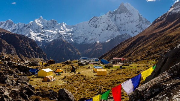
安纳普尔纳峰(Annapurna),海拔8091米,是世界第十高峰。安纳普尔纳峰属于喜马拉雅山脉,位于尼泊尔中北部。尼泊尔被誉为徒步者的天堂,环绕安纳...
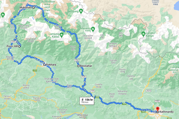
安纳普尔纳大环线是尼泊尔中部山脉的徒步旅行路线。这条路线的总长度在160-230公里,徒步旅行通常需要15-20天。通常从尼泊尔首都加德满都出发,中途在博卡拉(Pokhara)停留,然后返回首都。 这条世界著名徒步道难度从适度道到具有相当有挑战性,徒步过程多次跨越钢和木制吊桥。
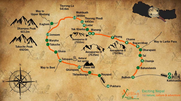
The Annapurna circuit trek is a hike within the Annapurna region around the entire Annapurna massifs including crossing the highest pass at Thorung La (5,416m), walking through the edge of the world’s deepest Kaligandaki gorge, as well as the sunrise view over the Himalayas from Poonhill, visiting Muktinath temple- the major pilgrimage destination, and refreshing in the natural hot spring at Tatopani. (discoveryworldtrekking.com)
安娜普纳峰群是以印度教的食物和营养女神Annapurna 命名的,据说她就住在那里。Annapurna这个名字来自梵语单词purna(“充满的”)和anna(“食物”)合成的,可以翻译为“永恒的食物”。许多小溪从安娜普纳山丘的斜坡上流下来,为地势较低的农田和牧场提供了水源。
安娜普纳峰群最高峰即安纳普尔纳I峰,译安纳布尔纳峰、安纳普尔那峰、安娜普尔纳峰、安娜普尔娜峰、安娜普娜峰。
Annapurna 是群峰(massif),属于尼泊尔中北部的喜马拉雅山脉,包括一个超过8000米山峰,13个超过7000米的山峰,16个超过6000米的山峰,群峰(massif)山体长55公里,西面是Kali Gandaki峡谷,北面和东面是Marshyangdi河,南面是Pokhara山谷。在西端,群峰环绕着一个高高的盆地,叫做安纳普尔纳圣殿。它的最高峰安纳普尔纳峰(英文: Annapurna I Main ),是世界上第十高的山,海拔8091米。1950年,莫里斯·赫尔佐格带领一支法国探险队从北坡登顶,使其成为有史以来第一个成功登顶的8000米高的山峰。
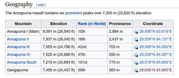
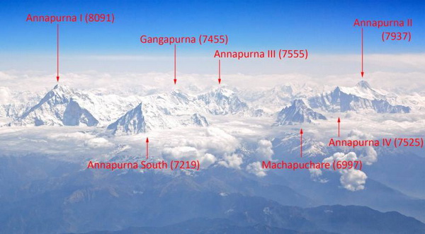
Annapurna is a massif in the Himalayas in north-central Nepal that includes one peak over 8,000 metres (26,247 ft), thirteen peaks over 7,000 metres (22,966 ft), and sixteen more over 6,000 metres (19,685 ft). The massif is 55 kilometres (34 mi) long, and is bounded by the Kali Gandaki Gorge on the west, the Marshyangdi River on the north and east, and by Pokhara Valley on the south. At the western end, the massif encloses a high basin called the Annapurna Sanctuary. The highest peak of the massif, Annapurna I Main, is the tenth highest mountain in the world at 8,091 metres (26,545 ft) above sea level. Maurice Herzog led a French expedition to its summit through the north face in 1950, making it the first eight-thousand meter peak ever successfully climbed. (wikipedia.org)
分享您对这篇攻略的问题或补充。评论会在发布前审核。
Hand-picked routes matched from this article's destination clues, tags, and categories.
结合这些景点信息,把周边看点与线路、目的地指南和旅行文章串联起来。
继续阅读与相似地点、主题和旅行问题相关的北京实用攻略。
订阅北京旅行灵感和线路更新。