Call a local advisor
+86 186 1196 4400Email our team
[email protected]Tour Beijing Journal
Plan your Xinjiang Tour? Xinjiang is a provincial level region, officially...
Xinjiang is roughly dissected into two parts by the UNESCO World Heritage crowned Xinjiang Tianshan ( Tianshan Mountain ) - the Northern Xinjiang and Southern Xinjiang. The northern Xinjiang mainly comprises the Junggar Basin, Altai Mountains while southern Xinjiang mainly comprises Tarim Basin, Taklamakan Desert and Kunlun Mountains.
The Southern Xinjing is synonymous with the old silk roads ( the north silk road north of Taklamakan Desert and the south silk road winding between the desert and Kunlun Mountains). The northern Xinjiang features a varied splendor of natural landscapes.
Looking for the top attractions in Xinjiang? Here is our version of Top 10 Places in Xinjiang.
Major attractions
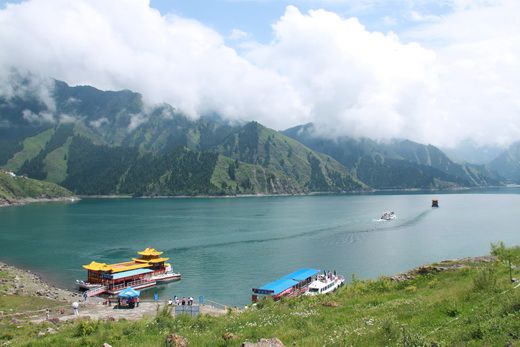
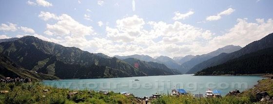
Tianchi ( Heavenly Lake) It is a crescent-shaped lake, 1,900 meters above sea level and as deep as 90 meters. The crystal-clear lake water is fed by melted ice and snow from the surrounding mountains. The lake is like a big mirror reflecting the snow-white peak and emerald-green spruce trees. Many visitors will take a 40-minute boat ride on the lake. If on a fine day, you can see the Bogda Peak (5545 above sea level). The Tianchi Lake is located north of the highest peak on the east of Bogda Peak, an ever snow-shrouded peak.
Xinjiang Uighur Autonomous Region Museum The Xinjiang Uighur Autonomous Region Museum was established in the spring of 1953 in the People’s Park in Urumqi. The museum boasts a collection of 32,000 cultural relics, 288 of which are of the national first class.The articles on display at the museum highlight archaeological finds from the Silk Road and local cultural relics.
Transportation: Urumqi has flights for the main big and medium-sized cities in China. You can take trains departing at Urumqi Station for Beijing, Shanghai, Lanzhou, Chongqing, Haikou, Urumqi, etc. Trains from Chengdu to Wuxi, Xi’an to Kuitun all stop at Urumqi Station. In addition, Urumqi has direct trains for Korla, Usu, Alataw Pass and Kashi. Urumqi Nianzigou Long-distance Bus Station has coaches for all major places in Xinjiang.
Turpan has extremely hot summers with low rainfall but high evaporation; long frost-free period and gusty winds; in central area, the tiptop temperature of 117℉. Make sure you come prepared if you visit during the summer months. Always carry plenty of drinking water, take some very strong sunblock and a good hat! The grade harvest season, namely July, August and September, is the best time for tourists to visit.
Major attractions
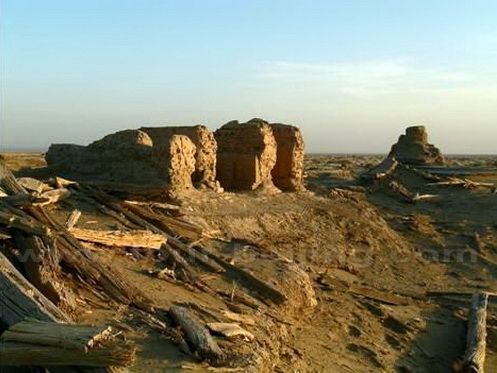
The Jiaohe Ruins is the site of an ancient city found, 10 km west of the city of Turpan. It is loacted on an island between two rivers, hence the name of "Jiaohe" "the confluence of two rivers." It was first built about 2,000 years ago and for a long period of time, was controlled by the residents of Gaochang.
Grape Valley Grape Valley is at the northeast of Turpan. It is a gully to the west of the Flaming Mountain. The valley runs 8 kilometers long, spans 0.6-2.0 kilometers wide. While the west side of the valley hangs sheer cliffs inside the valley is a forest of intertwined grape vines. Around the grape gardens towers vibrant poplar trees interspersed with a few flowers.
Flaming Mountain The Flaming Mountain is very popular thanks to a classical novel - the Journey to the West by the Ming Dynasty (1368-1644) writer, Wu Cheng'en and its charming hero - the Monkey King. The mountain lies 10 km (6.2miles) east of Turpan city, covering about 100 km (62miles) from east to west with a width of 9 km (5.6miles). The average height is 500m (1640feet), while the 831-meter (2726-foot) - high peak rises above Shengjinkou, a vital pass of the ancient city of Gaochang.
Transportation Turpan Railway Station is about 50kms from Turpan city, connected with Urumqi, Korla, Beijing, Shanghai and so on. Highway in Turpan is very developed. National highway 312 and 314 cross here. Tourists could take buss at Turpan Coach Station and Daheyan Coach Station to some major cities of Xinjiang. In summer the earliest bus starts at 7:30am, the latest at 20:30. And in winter the earliest is at 8:30am, the latest at 19:30.
Kuqa is located on the northern edge of the Tarism Basin, 280km west of Korla and 290km east of Aksu. The present Kuqa is a small, but friendly Uighur town. There is a great sunday market in the city center. It is worthwhile visiting the bazaar as well as the Great Mosque.
Major attractions
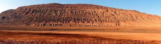
Tianshan Grand Canyon The Tianshan Mystery Canyon is located in the mountain area 72km north of Kuqa. The canyon is characterized by oddly-shaped rocks, craggy pinnacles, rugged cliffs and deep ravines. The width of the canyon changes due to the terrain. While the broadest area is 53 meter wide, the narrowest section is too narrow for one person to go through sideways.
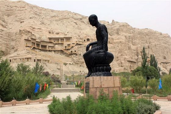
Kizil Thousand-Buddha Caves. The caves are located 67 kilometers west of Kucha County, the Kizil Thousand Buddha Caves is the oldest of its kind in China and the largest ruins of Buddhist culture in Xinjiang, even one century earlier than the famous Mogao Grottoes. There are now 236 numbered grottoes in this cave, which houses nearly 10,000 square meters of mural paintings.
Actually in Kuqa, there are totally 4 Thousand-Buddha Caves and other three are Subashi Site, Simsim Grottoes andKumtura Grottoes. Kuqa is now quite accessible either by road or train. The Urumqi-Kashgar train stops at Kuqa. You may also hire a car or van and drive directly from Korla or even from Urumqi. The cheap public bus is also available daily.
Major attractions
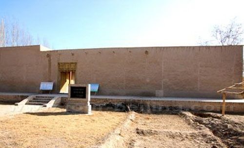
Abakh Khoja Tomb is the 17th Century family cemetery of the Kashgar area Islamic leader. In China the tomb is quite popular as the Tomb of Xiang Fei, the only Uigur concubine among the 41 wives of Emperor Qianlong in the Qing Dynasty (1644-1911). Abakh Khoja Tomb is famous as a well-preserved Islamic architectural complex not only in Xinjiang, but throughout Central Asia. Xiang Fei's love story entices tourists from home and abroad.
Id Kah Mosque The Id Kah Mosque is the largest mosque in China. Every Friday, it accommodates nearly 10,000 worshippers and may hold up to 20,000. The mosque was built by Saqsiz Mirza in ca. 1442.
Residential Area on High Platform The High Platform is Kashgar's old town. It is located on a natural slope of yellow soil, earthy and huddled with old houses, kept in reservation of part of the former Kashgar town. Most homes are handed down from generation to generation for over 300 to 400 years. The unique homes and antique soil earthenware workshops on soil precipice have become the two tourist attractions.
Grand (Sunday) Bazaar and Sunday Livestock Market Both Grand Bazaar and Sunday Livestock Market are the two major markets that attract a great number of tourists here to experience the real life in Kashgar.
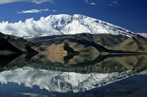
Karakuri Lake (Karakul Lake) It is 190km from Kashgar. It is rare highland lake in the world. By the lake ,there are yurst and restaurant available for tourists to stop and over night. In a day, you get a good view of Muztagh Ata and Kongur and snow-cappad peaks, flocks of animals, grassland are all invertedly reflected in the water, which looks magistic.
Transportation There are several daily flights from Kashgar to Urumqi. There are also regular trains going to Urumqi. Buses to Pakistan are available at Tuman Hotel beside the Tuman River. There are several buses running to Urumqi at cheaper offering. They depart from Tuman river. City transport is taxi, buses,bicycle instead of donkey cart.
Kongur Mountain (Gonggeer Shan) 公格尔山 Kongur Tagh or Kongkoerh is at 7,649 m the highest mountain wholly within the Xinjiang. It is situated just north of Muztagh Ata and can be seen from Karakul Lake. The construction of the Karakorum has made it more accessible.
Muztagh Ata (Mushitage Shan ) 慕士塔格峰 Muztagh Ata is at 7546 metres. It is often considered as being part of the Kunlun Shan, though physically it is more closely lined to the Pamirs. Muztagh Ata is located just south of Kongur Tagh, the highest peak of the Kunlun Mountain. Muztagh has been respected as the Father of Ice Mountains, well known for its magical world of glaciers.
Karakul Lake 卡拉湖 The Karakul Lake or Karakuli Lake is located about 196 km south of Kashgar on the Karakoram Highway. The lake is at 3600 meters, the highest lake on the Pamir plateau. Karakul Lake is surrounded by some snow-covered mountains and three of the highest peaks are Muztagh Ata (7,546 m), Kongur Tagh (7,649 m) and Kongur Tiube (7,530 m). Karakul Lake is a popular tourist destination with much camping activities.
Tashkurgan Town and Tashkurgan Fort 塔什库尔干镇 Tashkurgan, literally Stone Fortress or Stone Tower in Turkic. the main town and seat of Tashkurgan Tajik Autonomous County, Xinjiang. Tashkurgan is a market town for sheep, wool and woollen goods, particularly carpets. In Tashkurgan there is a museum that houses a few local artifacts, a photographic display and, in the basement, two mummies.
Khunjerab Pass The Khunjerab Pass is at the height of 4800 meters, China's gateway to Pakistan. The pass was used by caravans for centuries along the old silk road. Khunjerab, literally "Valley of Blood", telling the story of the local bandits plundering caravans and slaughtering merchants. Now the pass is the essential gateway going from China to Pakistan along Karakoram Highway. The border officially opens May to October.
Major attractions
Melikawat Ruins 玛利克瓦特古城 Melikawat is the ruins of an ancient and enormous Buddhist monastery located about 28 km south of central Hotan. Because the monastery was built along the Yorungkash River, most of the site has been buried in several meters of silt over more than a thousand years. Only a few eroding remnants of the tallest buildings emerge above the plain.
The Hetian Museum - The Hetian Museum was built in 1995. It contains over 9000 cultural relics; most of which were discovered by archaeologists after 1949, with a few donated by the locals. It has a floor space of more than 3,400 square metres. Its exhibits include textile technology, pottery, paintings and Buddhist culture.
Transportation There is no railway line passing through Hetian (Hotan). You can reach Hotan easily with daily flights from Urumqi, the capital of Xinjiang. Or travel on quality new sealed asphalt highways from Kashgar, Aksu, Korla and Urumqi.
Qiemo Old City is about 6 km southwest of the Qiemo's city center at the altitude of 1273, a relics site of desertification without any vegetation. Qiemo Old City was one of the 36 city kingdoms in the ancient West Region. Like the ancient cities of Loulan, Niya, the ancient Qiemo City has become a destination for adventurous travelers.
Major attractions
Qiemo Museum The museum houses the relics discovered in Qiemo area.
Toghrakiek Manor The Toghrakiek Manor is located in Togelakele Township, about 2.5 km west of Qiemo city. The manor was originally built in 1911 with a construction area of 780 square meters, square in shape. The manor was owned by the biggest landlord. The remaining manor comprises 11 rooms and 2 corridors, a architecture of earth and wood with ornate decoration.
Transportation Qiemo Bus Station has buses going to the major areas like Minfeng, Kashgar, Ruoqiang and more.
The old Ruoqiang area was the smallest kingdom of the 36 city kingdoms in the West Region with its recorded history back to the year of 36 BC in Han Dynasty. With its long history of culture exchange and openess, now Ruoqiang County has three national level relics sites - Loulan Ancient City, Miran Ancient City and Haitou Ancient City.
The most famous was Loulan Ancient City 260 km northeast of Ruoqiang Town. Miran Ancient City is 85 km northwest of Ruoqiang Town. To visit these far-flung relics sites, you'd better off joining other group tours with permits arranged by a local travel agency.
Transportation Ruoqiang was once the essential old town along the southern old silk road. The national highways of No. 218 and 315 pass through Ruoqiang, conveniently connected to the other parts of China.
Burjin got its name from Burjin river. From Xihan Dynasty to Qing Dynasty, Burjin had always been the nomadic land. Until in 1919, Altay attached Xinjiang province.
Climate: Burjin enjoys a dry and hot summer and a cold winter. The whole year is rainless and windy. There is great temperature difference in day and night.
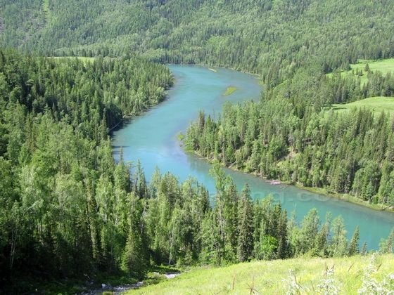
Kanas Lake The Kanas Lake (Kanasi Hu) means "beautiful, rich and mysterious" in Mongolian. The lake is nestled in the deep forests and mountains of Altay. The lake is 1,374m above sea level and covers an area of 45sqkm (10 times bigger than Tianchi on Bogda Mountain) with the deepest point of 188m.
The long bean-shaped lake reflects the surrounding snowcapped mountains. The tour guide on the boat says that the Kanas Lake in autumn is at its best with the beautiful foliage.
Legend has it that huge monsters live in the lake. They often has take away horses and camels drinking into the water by the lake and later swallow them, a similar story of "Nessie Monster".
Transportation Burjin is the transportation center of Altay area, national highway 217 crossed the city. There are sleeper bus trip between Urumqi and Burjin.
Major attractions
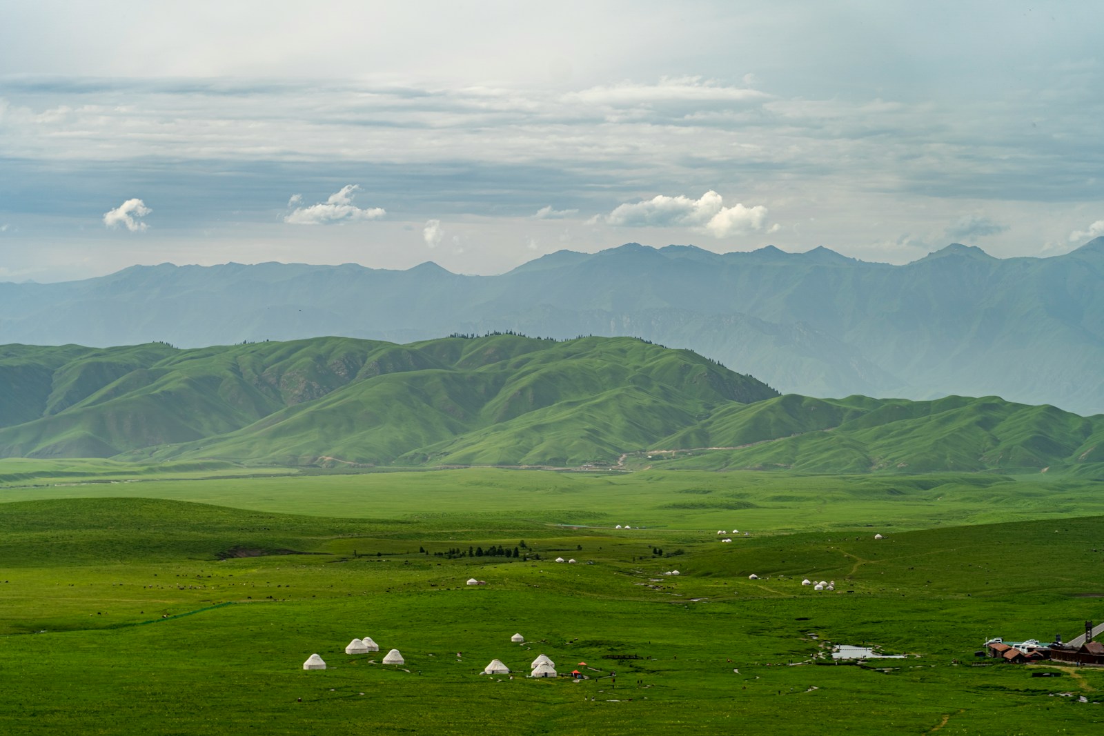
The Fruit Valley About 28km long stretching along in the rough direction of the Urumqi-Yining Highway, the Fruit Valley is a natural storehouse of plant species with a wide range of fruits and herbs growing wild in the area. In the valley, wild fruits and apricot trees spread all over the valley, and the rare trees and exotic flowers are everywhere. The valley takes on different outlooks in different seasons.
Narat Grassland is a typical river bed grassland and the alpine meadows. Narat Grassland is located at the sea-level of 1800 meters. It is inhabitated by Kazakh minority (but ironically, here in Narat Grassland, we, Han people are the minority.
Under the river bed grassland at Narat is the fertile black soil, which make the grass grow bere. It is said the grass can be grown as high as 70-90 cm in Sepetmber. In winter it is very cold on the river bed, reaching over - 40 degree below.
Transportation Airlines and highway are the main vehicles in Yining city. There is airline from Yining to Urumqi, taking about two hours. Wu-Yi Highway connects Yining, Shihezi and Urumqi. There are buses to Kuche and Kuerle southward.
Share a question or note for this guide. Comments are reviewed before publishing.
Hand-picked routes matched from this article's destination clues, tags, and categories.
Use these attraction notes to connect nearby sights with tours, destination guides, and planning articles.
Continue planning with practical Beijing guides selected from similar places, themes, and travel questions.
Subscribe to receive Beijing travel ideas and tour updates.