Call a local advisor
+86 186 1196 4400Email our team
[email protected]Tour Beijing Journal
Around 3:40 pm, 09 October, we start leaving Xinduqiao Town (新都桥镇). Mr.Chen...
Around 3:40 pm, 09 October, we start leaving Xinduqiao Town (新都桥镇). Mr.Chen fires up his engine and rolls his white beast and again picks up the National Highway G318 and drives west for our tonight's destination - Yajiang County (雅江县).
We choose to continue driving for extra 72km from Xinduqiao Town (Xinduqiaozhen on google map) to Yajiang partly due to the Yajiang's relatively low altitude of 2500 meters against Xinduqiao's altitude of 3450 meters; partly due to the fact today's extra 72km drive will reduce the intensity of our tomorrow's driving trip.
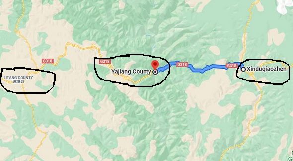
Yajiang's low altitude gains its reputation of being a nice stop between Kangding (or Xinduqiao ) and Litang (理塘) for G318 travelers including self-drive travelers, bicyclists, or hikers.
Yajiang is a modern town within the traditional Kham Region of the eastern Tibet, now under the administation of Ganzi Tibetan Autonomous Prefecture. Its splendid history brings people back to its prime days as the important stopover and ferry point for the ancient Tea and House Route.
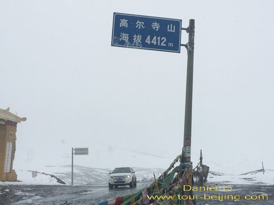
Now we are on the way from Xinduqiao to Yajiang. The driving map tells we have to get over a high pass known as Gaoersi Mountain Pass at 4412 meters sea level (高尔寺山海拔4412). Overcast and it is getting darker on the road up to the Gaoersi Mountain Pass. It starts snowing on the higher mountain road due to the changeable weather and cool temperatures at high altitudes.
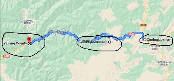
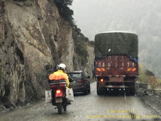
What makes things worse is the unrestored and unrenovated mountain road before and after the Gaoersi Mountain Pass and the terrible road turns out to be as long as 24 km! Actually you cannot call it "Highway" since it is very bumpy, muddy, messy and some sections of the horrible road don't have any guard rails to provent vehicles from straying into the deep gorges.
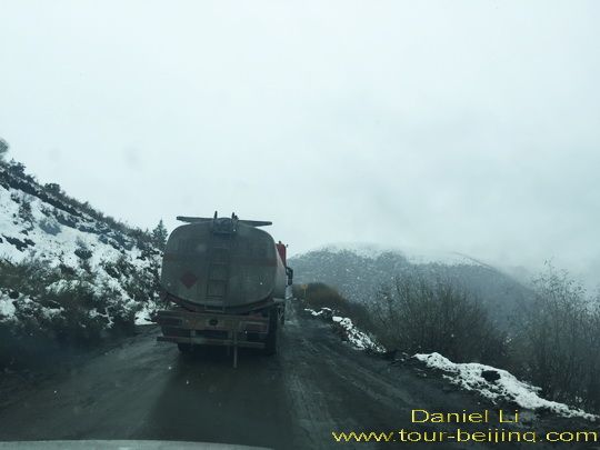
At 4:30 pm, we reach the Gaoersi Mountain Pass and see a signboard standing on the top with the words "Gaoersi Mountain Pass 4412 meters Altitude" in Chinese. We stop and stay there just for a few minutes, taking a photo of the signboard as a rememory and pay repect to the simple Gaoer Temple nearby with our eyes.
Driving over Gaoersi Mountain Pass, we find it is snowing heavily, making it even more difficult to drive along the muddy and bumpy road. We have to carefully steer clear of passing-by trucks, cars and even motorcyclists.
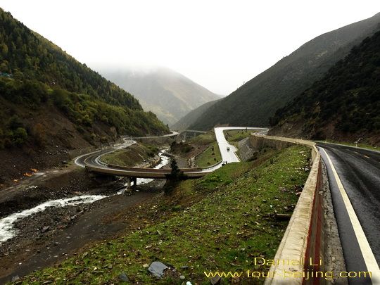
Eventually the highway condition is getting much better, and back to the normal level of a standard highway, wide and with guard rails. The road descends fast from the over 4000-meter-altitude Gaoersi Pass to a little over 2500-meter Yajiang.
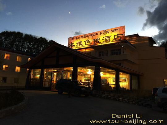
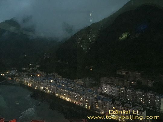
At 6:00pm, we arrive at the downtown of Yajiang County. It is a modern town set in the deep valley of Yalong River (雅砻江) which gives rise to the name of Yajiang. It is a 1,323 km long river, a tributary of the Yangtze River. Its source is on the Tibet-Qinghai Plateau in southeast Qinghai.
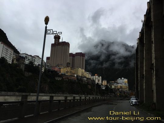
The town looks very much compact with crowded buildings cascading from the two sides of the river valley. It is a drab and dusty city but with some modern tall buildings standing here and there. There are also a few old side streets that betray an old town. Crowded buildings flank Yalong River cutting the town into two parts.
It doesn't take much efforts to secure two rooms at a nice hotel in Yajiang. But we do suggest you'd better reserve your hotel in Yajiang during the tourist peak season.
Any questions on the drive from Xinduqiao to Yajiang, just drop a line.
If you don’t want to go the do-it-yourself route and prefer the hassle-free escorted tours, here are some options for Chengdu and Sichuan guided tours:
Share a question or note for this guide. Comments are reviewed before publishing.
Hand-picked routes matched from this article's destination clues, tags, and categories.
Use these attraction notes to connect nearby sights with tours, destination guides, and planning articles.
Continue planning with practical Beijing guides selected from similar places, themes, and travel questions.
Subscribe to receive Beijing travel ideas and tour updates.